
Hamburg U-Bahn network map
The four lines (U1, U2, U3, U4) and 93 stations of the Hamburg metro at a glance, with every interchange marked. Download it as a PNG or as a printable PDF.
The Hamburg U-Bahn map explained
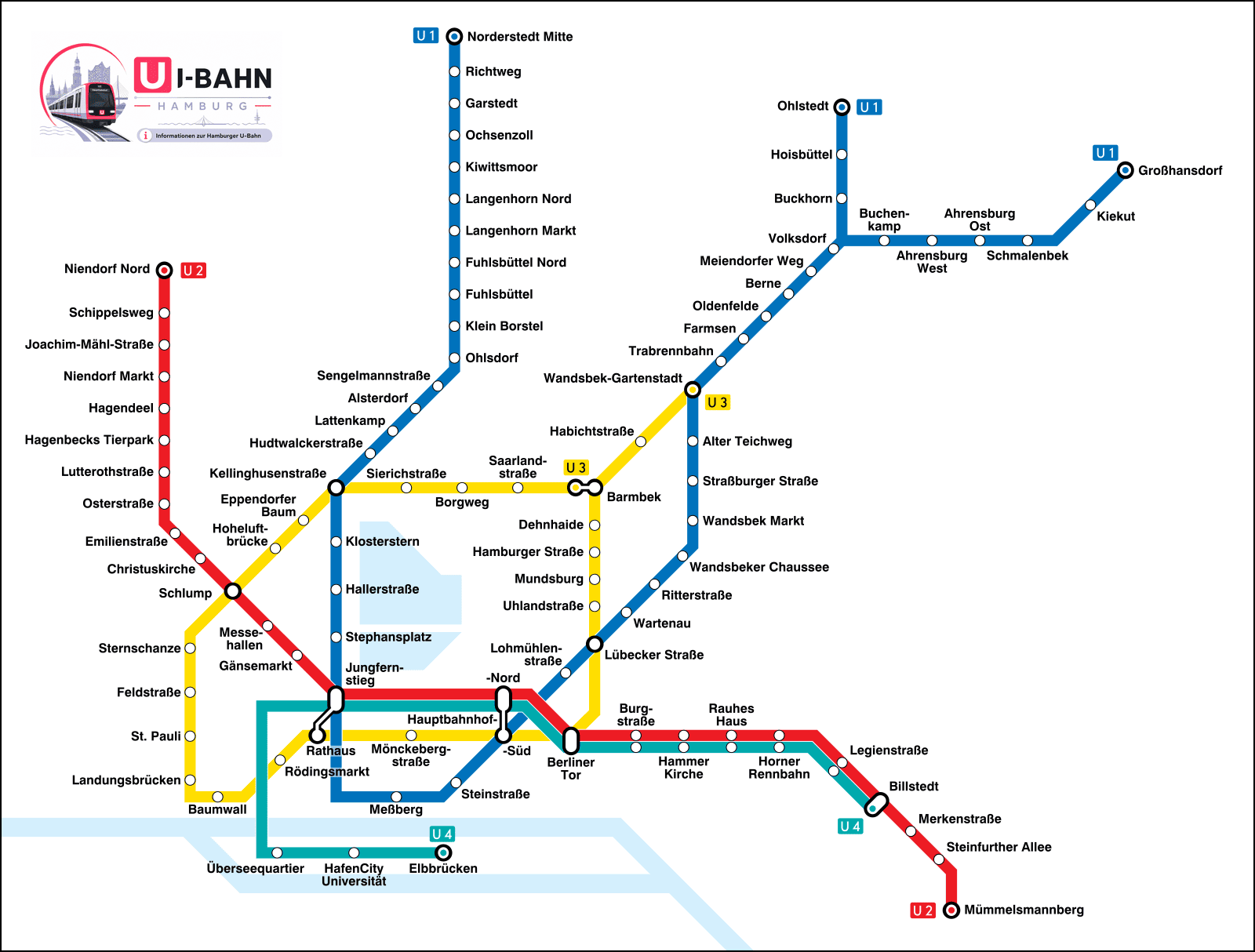
93 stations, 109 stops (interchanges counted once per line), about 106 km of track and 14 interchange stations.
Network map: © Arbalete, Wikimedia Commons, CC BY-SA 4.0
Hamburg U-Bahn map PDF — download
The Hamburg U-Bahn map as a PDF stays sharp when you zoom in or print it, and it works offline — handy down in the stations, where mobile coverage is patchy. You get all four lines, the 93 stations and the 14 interchange stations in your pocket.
Legend: the 4 lines and their colors
The Hamburg U-Bahn has four lines: U1 (blue), U2 (red), U3 (yellow) and U4 (teal). The U3 is a ring line, and the U4 is the newest line, running into the HafenCity. You will not find a U5 on the map — it is under construction and not in service yet.
The 14 interchange stations on the network
At 14 interchange stations you can change line without buying a new ticket: transfers are always included in the HVV fare. The busiest are Jungfernstieg (U1, U2, U4) and Berliner Tor (U2, U3, U4) — the two stations where three U-Bahn lines meet. Good to know: Hamburg’s main station has two separate U-Bahn stops — Hauptbahnhof Süd (U1/U3) and Hauptbahnhof Nord (U2/U4).
The U5 and U4 extension: what is being built
Hamburg is building two extensions to the U-Bahn network. The U5 will be a fully automatic, driverless line running right across the city (Bramfeld – City Nord – Universität – Stellingen/Arenen); the first sections are under construction and through service is not expected before the 2030s. The U4 is being extended beyond Horner Rennbahn to the Horner Geest (Stoltenstraße, Horner Geest), with an opening planned for around 2027. Neither is in service yet, so both are left off this site’s network for now.
In short: if you ride the U-Bahn in Hamburg today, you have four lines to choose from — U1, U2, U3 and U4. If you are looking for a U5 on the map, you will not find one yet; it and the U4 extension to the Horner Geest are still being built. That is not a misprint — it is simply where things stand today.
Hamburg U-Bahn map: frequently asked questions
Right here on this page: click «Map as PDF» and the file is saved to your device. The map is also available as a PNG. Both versions are free, print well and work without an internet connection.
4 lines (U1, U2, U3 and U4) and 93 stations. If you count the interchange stations once per line, you get 109 stops. The network is about 106 km long.
Because it is not in service yet. The U5 is being built as Hamburg’s first fully automatic, driverless line, running right across the city; the first sections are under construction and through service is not expected before the 2030s. The extension of the U4 to the Horner Geest is also still under construction.
Two of them: Jungfernstieg (U1, U2, U4) and Berliner Tor (U2, U3, U4) each connect three U-Bahn lines. The other interchange stations bring two lines together.
Yes. Hamburg has two separate U-Bahn stations at the Hauptbahnhof: Hauptbahnhof Süd (U1 and U3) and Hauptbahnhof Nord (U2 and U4). There is no cross-platform interchange between the U1 and the U2 — you walk briefly through the station concourse.
No. With a valid HVV ticket you can change as often as you like — between U-Bahn, S-Bahn, bus and harbor ferry within the fare zone. A single ticket for zone AB costs €4.10 and is valid for the whole journey in one direction.